 ES
SOMIEDO LAKES ROUTE
Somiedo Lakes route (PR.AS - 15)
Route type: Linear
Distance: 14 km
Duration: 4h 30min
Elevation gain: 400 m
Difficulty: Moderate
Route map and elevation profile
- Total ascent358 m
- Total descent701 m
- Highest point1,746 m
- Lowest point1,246 m
Elevation profile
Use two fingers to move the map
Track based on OpenStreetMap (© its contributors, ODbL licence); elevation from the Copernicus EU-DEM model. For guidance only: always follow the waymarks.
The Somiedo Lakes route (PR.AS-15) links the Saliencia lakes with Lago del Valle. It is a traverse: it starts at the Alto de La Farrapona pass and ends in the village of Valle de Lago, so it does not return to the starting point. If you only want to see the Saliencia lakes, there is a short out-and-back version.
Split times
Times from the Alto de La Farrapona, according to the official trail sheet:
| Point | Time |
|---|---|
| Lago de la Cueva | 20 min |
| Lago Cerveriz | 1 h 17 min |
| Lago Calabazosa | 1 h 24 min |
| Vega de Camayor | 2 h 06 min |
| Valle de Lago | 4 h 30 min |
The short version: just the Saliencia lakes
You do not need to complete the traverse to see the Saliencia lakes: you can walk there and back from La Farrapona. Lago de la Cueva is 20 minutes from the pass, along a gently descending track, and Calabazosa, the largest of the three, is 1 hour 24 minutes away, passing the Laguna de la Mina and Lago Cerveriz on the way. Walking to Calabazosa and back the same way takes about 3 hours.
How to organise the traverse
The full route ends in Valle de Lago, in a different valley, so you need to leave a car at each end or have someone pick you up at the finish. It can also be walked in reverse, starting from Valle de Lago, as explained at the end of the description.
Route description
From the village of Saliencia, the last settlement in the valley of the same name, a track suitable for vehicles leads to the Alto de la Farrapona or Collada de Balbarán, a pass into the Leonese municipality of San Emiliano. The walk starts here, with a fine view of the Las Ubiñas massif. A branch of the track turns back west to reach Lago de la Cueva after a gentle descent of about a kilometre. The scars left on the ground by iron mining at the Santa Rita mine, now abandoned, are still evident here.
The route continues along the old iron-mine track, climbing steeply past the Laguna de la Mina, dry in the summer months. A few minutes later the horizon opens and the splendid Cerveriz meadow comes into view, together with the lake of the same name, reached after a gentle descent.
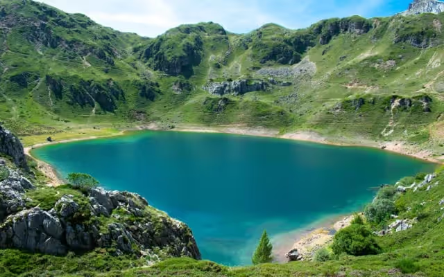
The path carries on south-east to reveal the magnificent sight of the great Lago de Calabazosa. This lake, the largest of the three, lies in the hollow of a large doline, dissolved out of the limestone and later sealed by glacial sediments. After going back to the Vega de Cerveriz, the route crosses it heading north-west and, at its far end, takes a path that climbs gently to a col to the north. This brings into view the impressive Vega de Camayor, with its gentle subalpine pastures and small pools.
After half an hour’s walk, always in the same direction, you reach the Llomba de Camayor, from where you can see the crests of Peña Llana, Cebolléu and Picos Albos. Here the path turns left and descends steadily until, before long, Lago del Valle and the meadows leading to the village of Valle de Lago come into view. From this point, a path that descends all the way reaches the track between Lago del Valle and the village, which is followed to the end.
Notes: if you walk the route starting from Valle de Lago, take the track that heads east, following the signs to the Saliencia lakes, up to the Llomba de Camayor, and cross the Camayor and Cerveriz meadows to the lakes. From the last one, follow the mine track until Lago de la Cueva comes into view.
Download the route map (PDF, in Spanish)When to go
The Alto de La Farrapona is often closed by snow in winter: outside summer, check that the road is open before you set out. The Laguna de la Mina dries up in the summer months.
Where to stay
For an early start, the most convenient option is to sleep in the Saliencia valley, on the way to La Farrapona, or in Valle del Lago, where the traverse ends.
Frequently asked questions
Where does the Somiedo Lakes route start?
At the Alto de La Farrapona, reached by car beyond the village of Saliencia.
How long does it take?
The full traverse to Valle de Lago is 14 km and four and a half hours. The short version, to Lago Calabazosa and back, takes about 3 hours.
Is it a circular route?
No. It is linear: it starts at La Farrapona and ends in Valle de Lago.
Which is the largest of the Saliencia lakes?
Calabazosa. The others are La Cueva and Cerveriz, plus the Laguna de la Mina, which dries up in summer.