 ES
VALLE DE PIGÜEÑA ROUTE
Valle de Pigüeña route (PR.AS - 14.1)
Route type: Out and back
Distance: 6 km
Duration: 2h 15min
Elevation gain: 500 m
Difficulty: Moderate
Route map and elevation profile
- Total ascent556 m
- Total descent5 m
- Highest point1,399 m
- Lowest point845 m
Elevation profile (one way)
Use two fingers to move the map
Track based on OpenStreetMap (© its contributors, ODbL licence); elevation from the Copernicus EU-DEM model. For guidance only: always follow the waymarks.
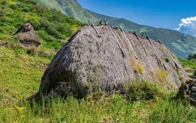
The Valle de Pigüeña route (PR.AS-14.1) leaves Villar de Vildas and follows the river Pigüeña upstream to the Braña de La Pornacal, with thirty-four teito cabins, the Corralón waterfall and the Braña Viella. The trail sheet gives 6 km, 500 m of ascent and 2 h 15 min one way; you return the same way.
Split times
Times from Villar de Vildas, according to the official trail sheet:
| Point | Time |
|---|---|
| Cotado bridge | 5 min |
| La Pornacal | 1 h 10 min |
| La Prida spring | 1 h 20 min |
| Corralón waterfall | 1 h 50 min |
| Braña Viella | 2 h 15 min |
These are one-way times: the return is by the same route.
Route description
The route starts in the hamlet of Villar de Vildas, where you leave the car and set off on foot along a track heading south. Shortly after leaving the village, the track crosses the river at the Cotado bridge, and the walk continues uphill along the left bank of the Pigüeña to La Pornacal.
The Braña de La Pornacal is one of the largest and best preserved in the Park. It is a group of thirty-four cabins, rectangular in plan and roofed with plant material, broom. The braña is the ideal place for a rest while looking across the river, to the west, at the great beech wood of Las Sendas, a refuge for the most representative animal species of the region. Setting off again, you can refill your water at the La Prida spring, almost at the southern end of the braña. The track continues up the valley in a gentle climb, leaving the broad meadows of La Requexada on the right. Early in the day, or at dusk, red deer or chamois can be seen grazing on the steep sides of the valley.
After La Requexada the valley narrows and the climb becomes steeper, soon reaching the Corralón waterfall and then the Braña Viella or Braña de los Cuartos, of an older type than the previous one, with round huts roofed with stone slabs, corros, in the primitive style of the Iron Age hillforts. The route ends here, beside the Los Cuartos spring, with its cold, clear water. From this point there is a splendid view of the beautiful Valle de los Cereizales, beyond which lie the Leonese valleys of Laciana.
The return is by the same route, leaving on the right, almost as you leave Braña Viella, the turn-off to the vaqueiro braña of La Peral (La Peral – Villar de Vildas route, PR.AS-14).
Notes: it is important to remember that the route described runs through a narrow strip of land classed as Agricultural Use, surrounded by Special Restricted Use areas that are closed to the public. Do not leave the waymarked route, so that enjoying the Park does not interfere with the conservation of the ecosystems that give these places their special value.
Download the route map (PDF, in Spanish)


