 ES
BRAÑA DE MUMIÁN ROUTE
Braña de Mumián route (PR.AS - 11)
Route type: Linear
Distance: 6.5 km
Duration: 2h 15min
Elevation gain: 170 m
Difficulty: Moderate
Route map and elevation profile
- Total ascent215 m
- Total descent474 m
- Highest point1,436 m
- Lowest point977 m
Elevation profile
Use two fingers to move the map
Track based on OpenStreetMap (© its contributors, ODbL licence); elevation from the Copernicus EU-DEM model. For guidance only: always follow the waymarks.
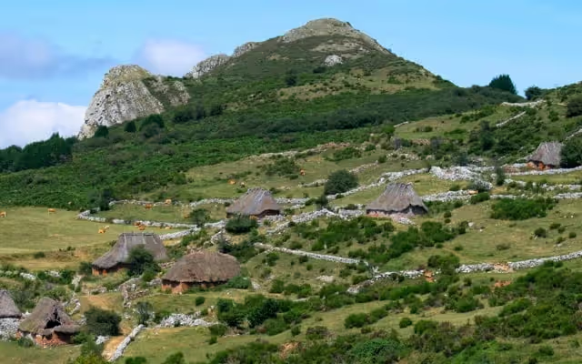
The Braña de Mumián route (PR.AS-11) starts at the vaqueiro braña of Llamardal, reached by a turn-off from the road from Pola de Somiedo to El Puerto once past Caunedo, and goes down to Coto de Buenamadre. On the way it passes the Braña de Mumián, with its teito cabins and the Fuente’l Cañu spring, and crosses the La Enramada beech wood. It is linear: 6.5 km, 170 m of ascent and 2 h 15 min; unless a car is waiting in Coto de Buenamadre, you return the same way.
Split times
Times from the road, according to the official trail sheet:
| Point | Time |
|---|---|
| El Llamardal | 15 min |
| Canto de La Mostallal | 40 min |
| Braña de Mumián | 1 h 10 min |
| Coto de Buenamadre | 2 h 15 min |
Route description
From the road that runs from Pola de Somiedo towards El Puerto, once past the village of Caunedo, take a turn-off on the left that leads to the vaqueiro braña of Llamardal, where the walk begins.
If you set out first thing in the morning, or at dusk, it is not hard to see chamois, roe deer or many species of birds.
The path starts in Llamardal, among the hay meadows that surround the hamlet. It climbs gently across the slope of Peña Gúa and then comes out into an area of hay meadows with stone boundaries between the plots, with patches of scrub here and there. The path continues between walls to the Fuente’l Cañu, in the Braña de Mumián, where you can see old olleras, structures once used to keep milk cool with running water.
It is worth stopping to rest beside the spout of clear water while taking in the layout of the teito cabins scattered across the meadow. The settlement and the landscape are very beautiful, with a fine view of Pico El Mocoso and the Sierra del Páramo opposite, on the other side of the valley of the river Somiedo.
You leave the braña through broom scrub dominated by common broom (Cytisus scoparius), whose branches are used to make the roofs of the cabins. The path then starts to descend and enters the La Enramada beech wood, an area classed as Restricted Use, so you must not leave the track and should walk in silence so as not to disturb the life of the forest. The path continues its steep zigzag descent, with excellent views of the hamlet of Urria through the clearings in the beech wood. The nearness of the village of Coto de Buenamadre starts to show in a change of vegetation, as the beech wood gives way to hay meadows with a great diversity of species, edged with hazel, hawthorn, maple and ash, among other less common species.
The return is by the same route, unless you have a vehicle in Coto de Buenamadre, which is reached from the Valle de Lago road by a turn-off to the right at Urria. You could also consider hiring transport for the way back.
Download the route map (PDF, in Spanish)


