 ES
ES Map of Somiedo Natural Park
Somiedo Natural Park covers 291 km² in south-western Asturias, on the border with León. It is organised into four valleys running north from the Cantabrian Mountains, and understanding them is the quickest way to orient yourself: almost everything worth visiting sits in one of them.
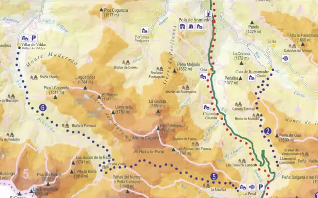
The four valleys
| Río Somiedo valley | Pola de Somiedo, Gúa, Caunedo, Veigas, La Riera AS-227 from Aguasmestas |
|---|---|
| Valle del Lago | Valle del Lago Turn-off from Pola de Somiedo |
| Saliencia | Saliencia, La Peral AS-227 towards the La Farrapona pass |
| Pigüeña valley | Villar de Vildas, Éndriga Turn-off at Aguasmestas |
Pola de Somiedo is the main village and the reference point on the map: the local roads to Valle del Lago, Saliencia and La Peral all start there.
Where the lakes are
The glacial lakes fall into two groups. Lago del Valle, the largest glacial lake in Asturias, lies at the head of its own valley and is reached on foot from the village of Valle del Lago. The Saliencia lakes —La Cueva, Cerveriz, La Mina and Calabazosa— sit high above Saliencia, and the shortest approach starts at the La Farrapona pass.
The trails on the map
The 13 waymarked routes in the park, shortest to longest:
- Senda Accesible — 2 Km, 1h
- Ruta de la Braña de Sousas — 3 Km, 1h 30min (PR.AS - 16.1)
- Ruta de Castro — 4 Km, 1h 30min (PR.AS - 13)
- Ruta de la Braña de Mumián — 6,5 Km, 2h 15min (PR.AS - 11)
- Ruta del Valle de Pigüeña — 6 Km, 2h 15min (PR.AS - 14.1)
- Ruta del Lago del Valle — 6 Km, 2h 30min (PR.AS - 15.1)
- Ruta del Cornón — 7 Km, 4h 30min (PR.AS - 10)
- Ruta de las Brañas de Saliencia — 8 Km, 3h 15min (PR.AS - 12)
- Ruta del Puerto - Valle del Lago — 9,5 Km, 4h 30min (PR.AS - 16)
- Ruta del Real Camín de la Mesa - La Bustariega — 9 Km, 3h (GR - 100)
- Ruta de La Peral - Villar de Vildas — 13 Km, 5h 15min (PR.AS - 14)
- Ruta de los Lagos de Somiedo — 14 Km, 4h 30min (PR.AS - 15)
- Ruta del Camín Real de la Mesa — 20,5 Km, 7h (GR - 101)
Getting there
The main access is the AS-227, which enters the concejo at Aguasmestas from the road between Oviedo and Belmonte de Miranda and climbs the valley to Pola de Somiedo and the Somiedo pass. From the south you come in from León over the Somiedo pass, and from the east from Teverga over the La Farrapona pass, which closes often in winter.
Equipamiento recomendado para tu visita


